Analysis of GPS Use for Determining Ship Course and Position on the MT New Winner
Analisis Pengaruh Alat Navigasi GPS Untuk Menentukan Arah dan Posisi di Kapal MT NEW WINNER
DOI:
https://doi.org/10.48192/vns.v13i1.740Keywords:
GPS, Electronic Navigation, System Integration, Position Fixing, MT New WinnerAbstract
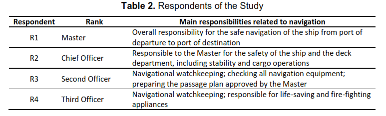
The Global Positioning System (GPS) is the primary source of position for modern ship navigation, and its value depends on how well it is integrated with other bridge equipment such as RADAR/ARPA, the Electronic Chart Display and Information System (ECDIS), and the Automatic Identification System (AIS). This study analyses the use of GPS for determining ship course and position on the tanker MT New Winner, identifies the factors that hinder its optimal use, and proposes solutions. A descriptive qualitative design was applied over 12 months of sea service, using observation on the bridge, semi-structured interviews with four deck officers (the Master and the Chief, Second, and Third Officers), and a review of manuals and literature. While the vessel was sailing in the Makassar Strait, GPS1 (Furuno GP-150), the only receiver interfaced with RADAR/ARPA, ECDIS, and AIS, failed. Although GPS2 (GP-170) still displayed the ship’s position, it was not connected to the other systems, so the Master had to plot the position manually every 30 minutes to avoid the risk of grounding. The failure was caused by a damaged GPS antenna and its mounting, broken antenna shock absorbers, poorly maintained cables and keys, and an inadequate power supply. The study concludes that GPS use on board was not optimal because of the lack of redundant integration and insufficient maintenance. Connecting both GPS units to all navigation systems, maintaining the antenna, cabling, and power supply regularly, and practising alternative position-fixing methods are recommended.
References
Androjna, A., & Perkovič, M. (2021). Impact of spoofing of navigation systems on maritime situational awareness. Transactions on Maritime Science, 10(2), 361–373. https://doi.org/10.7225/toms.v10.n02.w08
Androjna, A., Perkovič, M., Pavic, I., & Mišković, J. (2021). AIS data vulnerability indicated by a spoofing case-study. Applied Sciences, 11(11), Article 5015. https://doi.org/10.3390/app11115015
Antoro, D., Apriani, D. D., & Ikhsan, A. (2023). Optimising the use of radar in the navigation of KM. Bintan Utama in narrow channels. Hengkara Majaya, 4(1), 98–102. https://doi.org/10.61759/hmj.v4i1.67
Awan, M. S. K., & Al Ghamdi, M. A. (2019). Understanding the vulnerabilities in digital components of an integrated bridge system (IBS). Journal of Marine Science and Engineering, 7(10), Article 350. https://doi.org/10.3390/jmse7100350
Aylward, K., Weber, R., Lundh, M., MacKinnon, S. N., & Dahlman, J. (2022). Navigators’ views of a collision avoidance decision support system for maritime navigation. Journal of Navigation, 75(5), 1035–1048. https://doi.org/10.1017/S0373463322000510
Bhatti, J., & Humphreys, T. E. (2017). Hostile control of ships via false GPS signals: Demonstration and detection. NAVIGATION, 64(1), 51–66. https://doi.org/10.1002/navi.183
Bowditch, N. (2017). The American practical navigator (Pub. No. 9). National Geospatial-Intelligence Agency.
Car, M., Brčić, D., Žuškin, S., & Sviličić, B. (2020). The navigator’s aspect of PNC before and after ECDIS implementation: Facts and potential implications towards navigation safety improvement. Journal of Marine Science and Engineering, 8(11), Article 842. https://doi.org/10.3390/jmse8110842
Engler, E., Banyś, P., Engler, H.-G., Baldauf, M., & Sill Torres, F. (2021). Evaluation of PNT error limits using real world close encounters from AIS data. Journal of Marine Science and Engineering, 9(2), Article 149. https://doi.org/10.3390/jmse9020149
Furuno Electric Co., Ltd. (2014). Operator’s manual: DGPS navigator, GPS navigator, model GP-150/GP-170. Furuno Electric Co., Ltd.
Hofmann-Wellenhof, B., Lichtenegger, H., & Wasle, E. (2008). GNSS—Global navigation satellite systems: GPS, GLONASS, Galileo, and more. Springer. https://doi.org/10.1007/978-3-211-73017-1
International Maritime Organization. (2020). SOLAS: Consolidated edition 2020. International Maritime Organization.
Jung, B.-K., Park, C.-H., & Choi, W.-S. (2023). Accuracy of GNSS position stored in fishing boat location transmitters in comparison with that of DGPS position. Journal of Marine Science and Engineering, 11(7), Article 1277. https://doi.org/10.3390/jmse11071277
Kayisoglu, G., Bolat, P., & Tam, K. (2022). Evaluating SLIM-based human error probability for ECDIS cybersecurity in maritime. Journal of Navigation, 75(6), 1364–1388. https://doi.org/10.1017/S0373463322000534
Liu, Y., Li, S., Fu, Q., & Liu, Z. (2018). Impact assessment of GNSS spoofing attacks on INS/GNSS integrated navigation system. Sensors, 18(5), Article 1433. https://doi.org/10.3390/s18051433
Oruç, A., Gkioulos, V., & Katsikas, S. K. (2022). Towards a cyber-physical range for the integrated navigation system (INS). Journal of Marine Science and Engineering, 10(1), Article 107. https://doi.org/10.3390/jmse10010107
Purnomo, S. W., Rikardo, D., Sulistianto, J., & Anggeranika, V. (2023). Upaya peningkatan keterampilan kru kapal dalam penggunaan teknologi navigasi kapal [Efforts to improve crew skills in using ship navigation technology]. Zona Laut: Jurnal Inovasi Sains dan Teknologi Kelautan, 4(2), 152–158. https://doi.org/10.62012/zl.v4i2.26932
Radoš, K., Brkić, M., & Begušić, D. (2024). Recent advances on jamming and spoofing detection in GNSS. Sensors, 24(13), Article 4210. https://doi.org/10.3390/s24134210
Supriyono, H., & Sulistyo, A. (2014). Electronic navigation systems for merchant navy deck officers. Deepublish.
Sutryani, H., Dewi, A. K., & Wibowo, I. R. (2021). Use of navigation equipment to prevent ship accidents. Journal Marine Inside, 3(1), 44–51. https://doi.org/10.56943/ejmi.v3i1.28
Syibli, Y. M., & Nuryaman, D. (2021). The role of shipboard navigation equipment in improving the safety of navigation. Dinamika Bahari, 2(1), 39–48. https://doi.org/10.46484/db.v2i1.250
Tsimplis, M. N., & Papadas, S. (2019). Information technology in navigation: Problems in legal implementation and liability. Journal of Navigation, 72(4), 833–849. https://doi.org/10.1017/S0373463318001030
Wu, Z., Zhang, Y., Yang, Y., Liang, C., & Liu, R. (2020). Spoofing and anti-spoofing technologies of global navigation satellite system: A survey. IEEE Access, 8, 165444–165496. https://doi.org/10.1109/ACCESS.2020.3022294
Zalewski, P., & Bilewski, M. (2019). GNSS measurements model in ship handling simulators. IEEE Access, 7, 76428–76437. https://doi.org/10.1109/ACCESS.2019.2921860
Zidan, J., Adegoke, E. I., Kampert, E., Birrell, S. A., Ford, C. R., & Higgins, M. D. (2021). GNSS vulnerabilities and existing solutions: A review of the literature. IEEE Access, 9, 153960–153976. https://doi.org/10.1109/ACCESS.2020.2973759